NASA‑Class Satellite Data Unraveled the Real Cause of the Deadly 2025 Uttarkashi Flood; Revealing Ice Patch Collapse, Not a Cloudburst
A Himalayan Disaster Revisited
On 5 August 2025, the tranquil Himalayan village of Dharali in Uttarkashi district (Uttarakhand, India) was struck by one of the most devastating flash floods in recent memory — a calamity that razed homes, hotels and infrastructure, and claimed lives in a matter of minutes. Initial accounts attributed the disaster to a cloudburst, a term frequently used in mountain weather emergencies when intense rain overwhelms a region in a very short time.
But nearly seven months later, painstaking scientific investigation using advanced satellite data has dramatically changed the narrative: the deadly flood wasn’t triggered by torrential rain or glacial lake bursts — but by the sudden collapse of a high‑altitude ice patch, previously hidden from plain view. That revelation is reshaping our understanding of Himalayan hazards at a time when climate‑driven change is altering mountain landscapes.
Chapter 1: The 2025 Uttarkashi Flash Flood — What Happened?
The Setting: Dharali and the Upper Himalayas
Dharali sits perched on a narrow valley floor along the Khir Gad stream, which joins the larger Bhagirathi River, about 2,650–2,700 meters above sea level. This region’s steep topography and confined valley geometry make it uniquely vulnerable to high‑energy floods.
On that fateful August morning, villagers and visitors alike were awakened by a terrifying roar: a sudden, rapid surge of water, debris, rocks and ice rushing down from the upper slopes of the Srikanta Glacier region. In just moments, homes were obliterated; structures were buried under mud and boulders; and roads, marketplaces, and entire segments of the settlement vanished under chaotic debris flows.
Residents captured chilling video footage showing a brief, powerful peak in the mud‑laden water surge, followed by hours of slower flowing muddy torrents — a signature pattern that would later prove crucial in scientific analysis.
Early reports quoted preliminary estimates of multiple deaths and dozens still unaccounted for — figures that underscored the tragedy’s scale.
Chapter 2: The Early Hypotheses — Cloudburst and GLOF Theories
In the immediate aftermath, pundits, officials and news media repeated two common narratives:
- That an intense cloudburst — extremely heavy rain over a short duration — had triggered the flash flood.
- Or that a Glacial Lake Outburst Flood (GLOF) — caused by sudden release of water from a glacial lake — had unleashed the devastation.
Such hypotheses were not unfounded. Both cloudbursts and GLOFs have historically led to destructive floods in the Himalayas. The region’s dynamic climate, steep gradients, and retreating glaciers make these events high on the list of potential hazards.
However, these initial assumptions lacked rigorous scientific backing. Actual rainfall data from the period before the disaster showed only light to moderate rainfall — nowhere near the downpour required to qualify as a cloudburst. And thorough scans of the upper catchment revealed no significant glacial lakes that might have suddenly burst.
Instead, multiple investigations pointed toward alternative mechanisms — such as moraine collapse or slope failures — but none could conclusively explain how the flood initiated.
Chapter 3: Enter the Satellites — ISRO’s Game‑Changing Analysis
Nearly seven months after the disaster, scientists from the Indian Space Research Organisation (ISRO) unveiled a detailed cause analysis using sophisticated satellite intervention, digital elevation modeling and field‑corroborated video data. Their conclusion was both surprising and vitally significant.
The Hidden Culprit: Ice Patch Collapse
At elevations exceeding 5,200 meters above sea level, in a shaded plane beneath the Srikanta Glacier, sat what scientists call a nivation zone — a hollow where snow, firn and ice accumulate. This is not a true glacier system but a form of perennial ice retained year after year under snow cover.
In July 2025, for the first time in at least 15 years of satellite observations, ISRO’s data showed exposed ice patches in this zone — a sign that warming temperatures and glacier thinning had stripped away protective snow.
Suddenly — likely just hours before the flood — a substantial section of this exposed ice, estimated to cover around 0.25 square kilometers and weighing millions of kilograms, catastrophically collapsed. Gravity took over.
From Icefall to Devastation
Once the ice broke away, meltwater, ice fragments and debris raced down the mountain’s steep slopes — over 2,500 vertical meters within roughly nine kilometers of travel. The rapidly accelerating mass turned into a high‑energy debris flood, sweeping up loose soil, rocks and sediments as it descended, finally hitting Dharali with devastating force.
What made this flood different from rain‑driven floods — or even GLOFs — was the short‑lived yet highly concentrated release, with a quick peak followed by extended muddy flow. That behavior mirrors mass release events rather than rainfall or lake bursts.
The ISRO study dispelled the previous cloudburst and GLOF narratives definitively, using:
- Rainfall records confirming the absence of intense downpour
- Lack of glacial lakes in the upper watershed
- Satellite imagery tracking the ice patch’s disappearance after the event
- Terrain models showing the direct downhill path of the collapsed mass
Chapter 4: Why Ice Patch Failure Matters More Than Clouds
This discovery carries huge implications for Himalayan hazard science. Until now, ice patch failures of this kind were rarely reported in the region, often documented instead in Arctic or Greenland environments. But as the Himalayas warm and glaciers thin rapidly, such “silent ice hazards” are becoming more likely.
Why Ice Patches Collapse
Ice patches exist in microclimates where snow and ice persist beyond seasonal melt. But they rely on protective layers of snow and insulation. As global temperatures rise and snow cover shrinks, these ice bodies lose their buffering layer and become structurally unstable.
Unlike large glacier fronts or glacial lakes — which are easier to detect and monitor — these smaller features often go unnoticed in routine hazard mapping.
Chapter 5: The Geography and Geomorphology That Amplified Destruction
Dharali’s landscape amplified the effects of the ice collapse:
- A very narrow, funnel‑like valley focused the rushing debris toward the village.
- A steep gradient accelerated the material’s velocity.
- Loose sediments and old landslide deposits provided additional mass to the flow.
The result was not merely a flood but a heavy debris torrent — a powerful combination of water, ice, rock, and sediment carrying enormous kinetic energy.
This combo turned what might otherwise have been a high‑altitude ice fall into a disaster capable of leveling entire communities within minutes.
Chapter 6: The Human Toll and Infrastructure Impacts
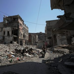
While news outlets initially reported several deaths and dozens missing, updated official figures over time placed the toll at a minimum of five confirmed fatalities, with many more still unaccounted for or missing. A significant portion of Dharali’s built environment — homes, guesthouses, shops, and roads — was buried under thick layers of mud and boulder debris.
In addition to loss of life and property, the flood also severed critical infrastructure links. Roads were scoured; bridges washed away; and telecommunication lines snapped. Emergency response units faced enormous access challenges due to destroyed connectivity and landslide threats.
Chapter 7: Rescue, Relief, and Rehabilitation Efforts
Within days of the disaster:
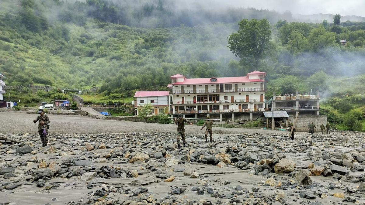
- The National Disaster Response Force (NDRF), state teams and the Indian Army launched joint rescue operations.
- Helicopters evacuated stranded residents and delivered essential supplies.
- Bailey bridges were erected to restore connectivity and enable relief convoys.
- Civil authorities began clearing debris and assessing the viability of resettlement in safer zones.
Despite these efforts, the event exposed glaring gaps in mountain disaster preparedness — especially regarding detection and early warning for non‑rainfall triggers like ice mass failures.
Chapter 8: What This Means for Climate Change and Himalayan Risk
The disaster in Dharali underscores a stark new reality: climate change isn’t just increasing rainfall intensity or monsoon extremes — it’s reconfiguring how hazards manifest in the Himalayas. As glaciers melt, normally stable features like ice patches and old permafrost zones are weakening and prone to sudden failure.
This has three major implications:
- Traditional hazard models — focused mainly on rainfall, cloudbursts and glacial lakes — may miss emerging risks.
- Small ice patches can cause outsized disasters when located above steep, vulnerable settlements.
- Satellite monitoring — especially radar capable of penetrating cloud cover — needs to become standard for early warning systems.
Scientists are now calling for integrated monitoring frameworks that combine:
- High‑resolution radar and optical satellite surveillance
- Ground‑level climate and glacier observation stations
- Community‑based early warning networks
- Terrain stability and vulnerability mapping
These measures could help pre‑empt not just rain‑driven hazards but also ice mass failures and other cryo‑hydrological threats.
Chapter 9: Policy, Preparedness, and the Path Forward
In the wake of this revelation, policymakers face urgent challenges:
- Update hazard classifications to include ice patch collapse risk zones.
- Revise land‑use and development rules for high‑altitude villages and tourism hotspots.
- Invest in advanced satellite monitoring and ground‑based climate networks.
- Educate local communities on signs of unusual ice behavior and slope instability.
The Indian Space Research Organisation’s work is a clarion call — not only for Uttarakhand but for Himalayan communities across India, Nepal, Bhutan, Pakistan and Tibet — that climate‑driven changes in mountain systems can produce hazards that traditional warnings miss.
This article may be prepared with the assistance of artificial intelligence (AI) and is reviewed before publication. While we aim for accuracy and timeliness, readers should verify important facts from official or primary sources. If you believe any information is inaccurate or that any content infringes your rights, please contact ainewsbreaking.com for review and appropriate action.