Severe Thunderstorm Warnings Issued Across New Jersey as Powerful Winds, Heavy Rain and Tornado Threat Loom
Severe weather has swept across parts of New Jersey, prompting urgent severe thunderstorm warnings and weather alerts as a dangerous storm system moves through the region with damaging wind gusts, heavy rainfall, and even the risk of tornadoes.
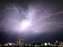
🌩️ Powerful Storm System Hits New Jersey
A strong line of storms moved into the Tri-State area, impacting New Jersey, Pennsylvania, and surrounding regions with intense weather conditions. Meteorologists warned that the system could produce wind gusts reaching up to 60–70 mph, capable of knocking down trees, damaging property, and causing power outages.
The storms intensified particularly during the evening hours, coinciding with peak travel time, creating hazardous conditions for commuters and residents alike.
⚠️ Severe Thunderstorm Warnings and Tornado Risk
Authorities issued severe thunderstorm warnings across several counties in New Jersey as conditions became increasingly unstable. In addition, a tornado watch was placed over parts of the state earlier in the day, signaling the possibility of isolated tornado development.
Although not all storms produced tornadoes, weather experts emphasized that the atmospheric conditions — including strong wind shear and instability — were favorable for rapidly developing severe storms.
At one point, tornado warnings were briefly issued in nearby regions, though they later expired as storms moved through.
💨 Damaging Winds Pose Biggest Threat
The most significant danger from this storm system has been powerful straight-line winds, which can be just as destructive as tornadoes.
- Wind gusts up to 70 mph reported in some areas
- Risk of fallen trees and power lines
- Potential for localized structural damage
Such winds are strong enough to cause widespread disruptions, especially in areas with older infrastructure or dense tree cover.
🌧️ Heavy Rain and Flooding Concerns
In addition to high winds, the storm system brought torrential rainfall, increasing the risk of flooding in low-lying and poorly drained areas.
Forecasters predicted:
- Rainfall totals between 1 to 3 inches in some locations
- Possibility of flash flooding in urban zones
- Water accumulation on roads, making driving dangerous
Some areas also faced the risk of minor river and stream flooding, especially where rain persisted for extended periods.
🚗 Travel Disruptions and Public Safety Warnings
Officials urged residents to exercise caution as the storms moved through. The combination of heavy rain, poor visibility, and strong winds made travel risky.
Authorities advised:
- Avoid unnecessary travel during peak storm hours
- Stay indoors and away from windows
- Secure loose outdoor objects
- Prepare for potential power outages
Commuters were especially affected, with evening travel becoming particularly hazardous due to the timing of the storm’s strongest impacts.
🌪️ Why These Storms Are So Dangerous
Severe thunderstorms like these can develop rapidly and produce multiple hazards at once. The current system is part of a larger weather pattern affecting much of the eastern United States, bringing a mix of strong winds, heavy precipitation, and severe weather outbreaks.
Meteorologists note that cold fronts interacting with warm, moist air often create the perfect environment for severe storms, especially in the spring transition period.
⏱️ When Will the Storms End?
The worst of the storms are expected to move out by late night, with calmer conditions gradually returning afterward. However:
- Cooler temperatures are expected behind the system
- Lingering showers may persist in some areas
- Conditions could stabilize by early the next day
🧭 What Residents Should Do Now
If you are in or near affected areas in New Jersey, experts recommend staying alert and monitoring official weather updates.
Key safety tips:
- Keep your phone charged and emergency alerts enabled
- Have flashlights and emergency supplies ready
- Move to a basement or interior room if a warning is issued
- Avoid flooded roads — “Turn around, don’t drown”
This article may be prepared with the assistance of artificial intelligence (AI) and is reviewed before publication. While we aim for accuracy and timeliness, readers should verify important facts from official or primary sources. If you believe any information is inaccurate or that any content infringes your rights, please contact ainewsbreaking.com for review and appropriate action.