Powerful 7.8 Quake Hits Southern Philippines, Triggering Tsunami Warning and Emergency Response Measures
powerful quake southern:
A powerful 7.8-magnitude earthquake struck Mindanao in the southern Philippines, prompting a tsunami alert from monitoring agencies.
Authorities are assessing potential damage while warning residents in coastal areas to move to higher ground. No confirmed casualty figures have been released so far, and aftershocks remain a concern.
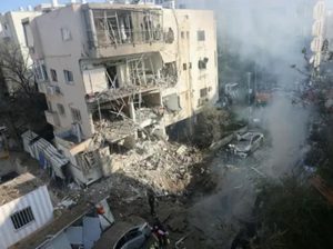
A powerful earthquake measuring 7.8 on the Richter scale struck the southern Philippine island of Mindanao, prompting immediate tsunami warnings and emergency response measures across coastal regions, according to the United States Geological Survey (USGS).
The quake, one of the strongest seismic events recorded in the region in recent years, caused intense shaking that was felt across large parts of southern Philippines. Authorities quickly issued tsunami alerts for vulnerable coastal zones, urging residents to move to higher ground as a precaution against potential wave activity triggered by undersea displacement.
As of initial reports, there have been no confirmed casualty figures, but emergency services have been mobilized to assess structural damage, infrastructure disruption, and the possibility of secondary hazards such as landslides and aftershocks.
Preliminary data from the USGS indicates that the earthquake originated offshore or near coastal fault systems in the Mindanao region, an area known for high seismic activity due to its location along the Pacific “Ring of Fire.”
This tectonically active zone is characterized by the convergence of multiple tectonic plates, making it highly susceptible to earthquakes, volcanic activity, and tsunami-generating events.
Mindanao, in particular, has experienced several significant earthquakes in the past, though events of this magnitude are less frequent and tend to generate widespread concern due to their potential to trigger tsunamis along surrounding coastlines.
Following the earthquake, tsunami warning systems were activated for coastal regions in and around Mindanao. Authorities cautioned that seismic activity of this magnitude, especially when occurring under or near the ocean, has the potential to displace large volumes of water, generating waves that could impact shorelines within minutes to hours.
Residents in low-lying coastal areas were advised to evacuate to higher ground and remain alert for further instructions from disaster management agencies.
While tsunami alerts do not always result in significant wave formation, they are issued as a precautionary measure whenever seismic conditions meet the threshold for potential sea displacement.
Emergency Response and Early Assessments : Philippine disaster response agencies rapidly began coordinating emergency protocols, including rapid assessment teams, communication alerts, and coordination with local government units.
Emergency services typically focus on:
- Rapid damage assessment of infrastructure
- Monitoring coastal water levels
- Checking for road and bridge integrity
- Establishing evacuation centers if needed
- Coordinating medical response teams
At this stage, officials are still gathering data from affected areas, particularly remote coastal and inland communities where communication may be temporarily disrupted due to infrastructure strain.
From a geological perspective, a 7.8-magnitude earthquake represents a major release of energy along a fault line. Such events are typically caused by sudden movement between tectonic plates that have been locked under stress for extended periods.
The energy released travels as seismic waves, which cause ground shaking and, in underwater settings, can displace large volumes of water—potentially triggering tsunamis.
Seismologists will continue to analyze waveform data to better understand fault mechanics, rupture length, and stress distribution associated with this event.
A 7.8-magnitude quake in the Philippines is not just an isolated natural disaster event—it is part of a recurring high-energy seismic regime driven by complex plate interactions in the Ring of Fire. The immediate tsunami alert reflects standard hazard modeling based on vertical seafloor displacement risk. What matters most in the coming hours is not just magnitude, but rupture depth, fault type, and whether slip occurred offshore. Historically, early tsunami warnings in this region are often precautionary and later downgraded, but the real structural risk lies in aftershocks and infrastructure vulnerability. In densely populated coastal geographies like Mindanao, even moderate wave activity or ground instability can translate into disproportionate humanitarian and logistical impacts.
This is a developing story. More updates will follow as new information becomes available.