 IIT Bombay scholar builds low cost air purifier starting at ₹2,000, can bring down AQI by 85% – How he did it? Details
  Colgate’s whitening toothpaste is 47% off today, and it’s not on the FDA’s recall list
  CPI(M) turns the heat on Keralam govt. over SMA drug controversy
  Finnish puppy livestream boosts pet ownership and sales.
 WMO El Niño Alert: ‘Very Strong’ 2026-27 Event Could Bring Extreme Heat, Drought and Floods Across the World
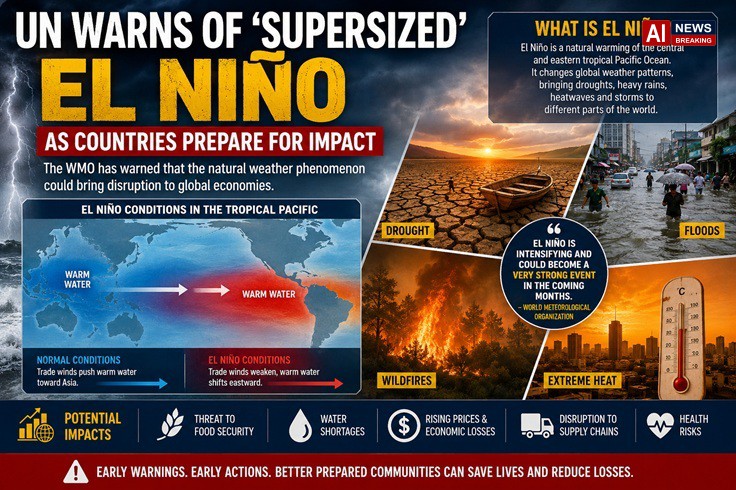
WMO El Niño Alert: 'Very Strong' 202627 Event Could Bring Extreme Heat, Drought and Floods Across the World - AI News Breaking
alert very strong 202627:
The world is entering a potentially dangerous new phase of climate variability as the World Meteorological Organization (WMO) warns that the El Niño weather phenomenon developing in the tropical Pacific is rapidly intensifying and could become a very strong event later this year.
In its latest update issued on September 3, 2026, the United Nations weather agency said El Niño is now firmly established and is expected to strengthen substantially in the coming months. The intensifying phenomenon is likely to alter rainfall and temperature patterns across large parts of the planet, raising the risks of extreme heat, drought, flooding and other weather-related hazards.
The warning has prompted governments and climate-sensitive industries to step up preparations for a period that could extend well into 2027. Agriculture, water management, energy, transportation, fisheries and public health are among the sectors that could experience significant disruption if the event reaches the strength currently anticipated by climate models.
Although headlines have increasingly described the developing phenomenon as a “supersized” or “super” El Niño, the WMO itself does not use “super El Niño” as an official classification. The agency categorises El Niño events as weak, moderate, strong or very strong. The latest warning indicates that the current event could move into the very strong category.
What is El Niño and why is the world concerned?
El Niño is a naturally occurring climate phenomenon associated with unusually warm sea-surface temperatures in the central and eastern tropical Pacific Ocean. It forms as part of the broader El Niño-Southern Oscillation, or ENSO, one of the most important drivers of year-to-year climate variability.
Under normal conditions, trade winds push warm surface water toward the western Pacific. During El Niño, those winds weaken or undergo significant changes, allowing warmer water to shift eastward. This changes the distribution of heat and moisture across the tropical Pacific and can influence atmospheric circulation far beyond the Pacific basin.
The consequences are not uniform. One region can experience unusually heavy rainfall and flooding while another faces drought and water shortages. Some countries can experience warmer-than-normal temperatures, while others see altered seasonal weather patterns.
The intensity, timing and duration of an El Niño event also matter. The interaction between El Niño and other climate patterns can make its effects more complicated and sometimes more severe.
The WMO says El Niño events generally occur every two to seven years and typically last between nine and 12 months. They often begin developing between March and June, reach maximum intensity between November and February, and can exert a particularly strong influence on global temperatures during the year following their onset.
The current event is therefore particularly significant because its projected peak is still ahead.
WMO says El Niño is strengthening rapidly
The latest WMO assessment represents an escalation from warnings issued earlier this year.
In June, the organisation said there was an approximately 80% probability that El Niño conditions would develop during June-August 2026, with the probability rising to around 90% through the later forecast period. At that stage, climate models suggested the event would probably be at least moderate, with the possibility of becoming strong.
By late July, the signal had strengthened considerably.
The WMO said in its July 31 update that a strong El Niño was developing and expected to intensify during August-October. Its multi-model ensemble forecast suggested seasonal-average sea-surface temperature anomalies of approximately 2.9°C in key monitoring regions during that period, with the intensification trajectory expected to peak around November.
The latest September assessment now says the event is firmly established and will intensify into a very strong event in the coming months.
That progression is important because ocean temperatures in the tropical Pacific are a key indicator of the strength of El Niño. As the ocean warms, its interaction with the atmosphere can increasingly influence global circulation patterns.
The WMO has stressed that the developing El Niño is occurring against a backdrop of exceptionally warm global oceans and elevated global temperatures. This means the consequences cannot be viewed in isolation from the broader climate system.
Why the word ‘supersized’ is appearing in headlines
The phrase “supersized El Niño” has gained attention because scientists and observers are warning of an unusually powerful event.
However, there is an important distinction between media terminology and scientific classification.
The WMO does not officially classify events as “super El Niño”. Instead, it uses categories including weak, moderate, strong and very strong. The latest warning points toward the upper end of that scale.
This distinction matters because the phrase “super El Niño” can sometimes create the impression that scientists are predicting a precise event with a formally defined category. They are not.
What is clear is that the current El Niño is strengthening rapidly and that several independent climate signals are pointing toward substantial impacts.
The WMO’s forecasts also emphasise probabilities rather than certainty. A region shown as likely to receive above-average rainfall, for example, is not guaranteed to experience it. Weather outcomes depend on numerous interacting atmospheric and oceanic processes.
Nevertheless, the broad signal is strong enough for governments and institutions to begin preparing.
Extreme heat could become one of the biggest threats
One of the most important consequences of a powerful El Niño is its contribution to global temperature patterns.
El Niño shifts large amounts of heat within the ocean-atmosphere system. During strong events, this can contribute to an increase in global average temperatures.
The WMO’s August-October outlook predicted above-normal temperatures across much of the world. Strong temperature signals were identified across Africa, southern Europe, the Arabian Peninsula, the Indian subcontinent, eastern Asia, Central America, the Caribbean, southern Africa, much of South America and New Zealand.
This is particularly concerning because the planet is already experiencing long-term warming caused primarily by human emissions of greenhouse gases.
El Niño is a natural phenomenon, but it can temporarily add additional warming to an already warmer climate system.
That combination can increase the likelihood of dangerous heat episodes.
Extreme heat can affect nearly every part of society. High temperatures can increase demand for electricity as households and businesses use more air conditioning. At the same time, heat can reduce the efficiency of power infrastructure and increase stress on electricity grids.
Agricultural productivity can also suffer when high temperatures coincide with inadequate rainfall. Crops may require more water precisely when water supplies are under pressure.
Human health is another major concern. Prolonged heat can increase the risk of heat exhaustion, heatstroke and other heat-related illnesses, particularly among older people, outdoor workers and vulnerable populations.
Drought and flooding: two sides of the same climate phenomenon
One of the defining features of El Niño is that its impacts can be contradictory.
A strong El Niño does not simply mean that the entire planet becomes hotter and drier. Instead, it can reorganise rainfall patterns.
Some regions can receive excessive rainfall and experience flooding, landslides and infrastructure damage.
Other regions can receive substantially less rainfall, increasing drought and wildfire risks.
The WMO’s August-October outlook identified a classic El Niño rainfall pattern, with wetter-than-normal conditions expected in parts of the Greater Horn of Africa, Central Asia, southern Europe, western North America south of 45 degrees north and southeastern South America.
At the same time, drier-than-normal conditions were more likely across the Indian subcontinent, southern and eastern Australia, southern Central America and parts of the Caribbean, northwestern South America and northern Europe.
This geographical contrast is one reason why the economic consequences of El Niño can be difficult to predict.
A country suffering drought may face declining agricultural production and water shortages, while another country simultaneously deals with flood damage to roads, homes, bridges and farms.
India faces particular concerns
India is one of the countries closely watching the development of El Niño because of its relationship with the South Asian monsoon.
El Niño does not automatically mean that India’s monsoon will fail. The relationship is complex, and other atmospheric and oceanic factors can influence the outcome.
However, historically, El Niño has often been associated with weaker or disrupted monsoon conditions in India.
The concern is particularly significant this year because rainfall performance has already become uneven.
India’s August rainfall was reported to be 16% below normal, and the India Meteorological Department forecast below-normal rainfall for September, with rainfall expected to be below 91% of the long-term average. The strengthening El Niño was identified as one of the factors contributing to concern over the remainder of the monsoon season.
For India’s agricultural economy, the timing is critical.
Crops including cotton, soybean, maize and pulses depend on adequate rainfall during important stages of development. Reduced soil moisture can also create problems for the next agricultural season, particularly for winter crops.
India remains heavily dependent on rainfall for agriculture. A substantial portion of farmland does not have reliable irrigation, making changes in monsoon rainfall particularly consequential.
A weaker overall monsoon does not necessarily mean every part of India will be dry.
Instead, rainfall may become more erratic, with long dry periods interrupted by intense downpours. Such a pattern can be particularly damaging because heavy rainfall over a short period may generate flooding without adequately replenishing soil moisture or groundwater.
This is one of the reasons meteorologists caution against interpreting El Niño solely as a “less rain” phenomenon.
Rainfall volatility may become a bigger problem
The distinction between rainfall quantity and rainfall distribution is increasingly important.
A region could record near-normal rainfall over an entire season while still experiencing severe agricultural and water-management problems if most of the rain falls during a few intense episodes.
For farmers, consistent rainfall during critical crop-growth stages can be more valuable than the same amount arriving in a few extreme storms.
Heavy rainfall can also cause erosion, flooding and landslides.
Urban areas face another challenge. Rapidly growing cities often have drainage systems that struggle to handle sudden extreme rainfall. Even a short period of intense precipitation can overwhelm drains and cause significant disruption.
This means that an El Niño-related shift toward greater rainfall extremes could affect infrastructure even where annual rainfall totals do not appear exceptionally unusual.
Positive Indian Ocean Dipole adds another layer of uncertainty
The Pacific Ocean is not the only oceanic factor being monitored.
The WMO has also highlighted the possibility of a positive Indian Ocean Dipole, or IOD, developing alongside El Niño.
The Indian Ocean Dipole is a climate pattern involving differences in sea-surface temperatures between the western and eastern tropical Indian Ocean.
A positive IOD can interact with El Niño and modify its effects on rainfall patterns, particularly around the Indian Ocean basin.
The WMO’s July assessment said that the developing El Niño was expected to occur alongside exceptionally warm global oceans and a likely positive IOD. The combination could amplify regional risks involving drought, flooding and wildfires.
The interaction between multiple climate drivers makes seasonal forecasting challenging.
Meteorologists therefore look not only at El Niño itself but also at the wider ocean-atmosphere system.
Southeast Asia and Australia prepare for hotter and drier conditions
Parts of Southeast Asia and Australia are among the regions where a strong El Niño can produce significant dry-weather risks.
In Indonesia, authorities have already been dealing with wildfire concerns. The country’s forestry minister warned on September 1 that efforts to control widespread wildfires would face major challenges as El Niño reached a critical phase. Hotter and drier conditions associated with El Niño can increase the risk and intensity of fires, although human activity remains a major factor in many individual fire events.
Wildfires can produce consequences far beyond the areas where flames are burning.
Smoke pollution can affect public health, aviation and transportation. Fires can damage forests and agricultural land while also creating significant economic losses.
Drier conditions can also place pressure on reservoirs and groundwater supplies.
Australia, meanwhile, is among the regions identified in the WMO’s outlook as having elevated drought risk during the August-October period.
Agriculture, livestock and water-intensive industries can all be affected when rainfall falls below expectations.
Latin America could face floods, drought and agricultural disruption
The Americas are also expected to experience significant changes in weather patterns.
El Niño is traditionally associated with altered rainfall across parts of South America, including increased rainfall and flooding in some areas and drought in others.
Peru is already preparing for serious consequences.
Peruvian authorities have warned that around 1.2 million people could be at risk as El Niño intensifies, particularly from November onward. At least 10 regions have been identified as vulnerable to flooding and mudslides, while hundreds of districts have been placed under emergency measures related to rain, flooding and potential water shortages.
Agricultural regions are particularly vulnerable.
Heavy rainfall can destroy crops and livestock, damage roads and disrupt supply chains. Flooding can also affect ports and transportation networks, making it more difficult to move food and other commodities.
At the same time, other parts of Latin America can face drought conditions, creating a complicated regional picture.
Fisheries could be hit by changing ocean conditions
El Niño can have profound effects on marine ecosystems.
Changes in sea-surface temperatures and ocean circulation can affect nutrient availability in coastal waters. This is especially important for fisheries that depend on cold, nutrient-rich waters.
Peru and Chile are among the countries where changes in ocean conditions can have significant economic consequences.
Fishing communities may face reduced catches or shifts in the distribution of commercially important species.
The consequences can extend through global commodity markets.
Fishmeal and fish oil are major products of industrial fishing and are used in animal feed and other industries. A significant reduction in catches can therefore affect prices and producers far beyond South America.
Shipping and global supply chains are vulnerable
The economic impact of El Niño is not restricted to agriculture and fisheries.
Weather extremes can disrupt global transportation networks.
Drought can affect waterways that are essential for international trade. The Panama Canal, for example, has already faced concerns related to water availability during periods of dry weather.
When water levels decline, authorities can restrict vessel movements or impose operational limitations.
That can increase shipping costs and create delays.
A disruption at a major maritime chokepoint can have consequences throughout global supply chains because ships may have to wait longer, reduce cargo loads or take alternative routes.
The result can be higher transportation costs and delays in delivering raw materials and manufactured products.
The potential for such disruption is particularly important in an already fragile global economy where companies are dealing with geopolitical tensions, energy-price volatility and supply-chain uncertainty.
Agriculture faces a complex global test
Perhaps no sector is more exposed to El Niño than agriculture.
Crops depend on predictable combinations of rainfall, temperature and soil moisture.
A strong El Niño can disrupt all three.
Drought can reduce yields by limiting water availability.
Excessive rainfall can destroy crops through flooding, waterlogging and erosion.
Extreme heat can accelerate crop development, reduce yields and increase water requirements.
The simultaneous occurrence of different conditions across different agricultural regions can also create volatility in global commodity markets.
If several major producing regions experience poor harvests, food prices can rise.
Higher prices can disproportionately affect low-income households because food accounts for a larger share of their household budgets.
Governments may then face pressure to release strategic food stocks, restrict exports, subsidise consumers or support farmers.
Food security risks could spread beyond directly affected countries
Climate-related shocks can spread through trade.
A drought in one major grain-producing country can increase international prices. Import-dependent countries may then have to pay more for food even if their own weather remains relatively normal.
The same applies to livestock feed.
Changes in the availability or price of crops such as maize and soybeans can raise production costs for meat, dairy and poultry industries.
This creates a chain reaction:
Extreme weather → lower agricultural production → tighter supplies → higher commodity prices → increased food costs → greater pressure on consumers and governments.
For poorer countries, the impact can be particularly severe.
Food-price inflation can worsen existing poverty and increase humanitarian needs.
Energy markets may also feel the effects
The energy sector is another area where weather variability can create economic consequences.
Extreme heat can increase electricity demand as consumers rely more heavily on cooling systems.
At the same time, drought can reduce hydropower generation in regions dependent on reservoirs and rivers.
Low water levels can also interfere with some forms of thermal power generation because power plants may depend on water for cooling.
Meanwhile, extreme weather can damage electricity transmission infrastructure.
The result can be a combination of increased demand and reduced supply, putting additional pressure on electricity grids.
Countries with limited grid capacity may face difficult decisions over energy allocation during periods of extreme heat.
Health systems could face additional pressure
The public-health implications of a strong El Niño extend beyond heatstroke.
Changes in temperature and rainfall can alter the geographic distribution of mosquitoes and other disease vectors.
Flooding can increase the risk of water contamination and some infectious diseases, while drought can create problems with sanitation and access to clean water.
Smoke from wildfires can aggravate respiratory conditions and increase demand for healthcare services.
Extreme heat can also affect workers, particularly those employed outdoors in agriculture, construction, transport and other physically demanding occupations.
Public-health authorities therefore need to prepare not only for one hazard but for multiple overlapping hazards.
Developing countries are particularly vulnerable
The physical impact of an extreme weather event does not automatically determine its economic damage.
A country with strong infrastructure, effective early-warning systems and sufficient financial resources may be able to absorb a major shock more effectively than a poorer country.
This is why international climate organisations emphasise early action.
A drought forecast months in advance gives farmers an opportunity to change planting decisions.
A flood warning gives communities time to evacuate.
A heat forecast allows hospitals to prepare for increased patient numbers.
Water authorities can adjust reservoir management.
Governments can strengthen food reserves.
Insurance companies can assess exposure.
The WMO has therefore emphasised that forecasts provide a window for early action and decision-making.
The world has a narrow preparation window
One of the central messages from the WMO is that governments should not wait until extreme weather occurs before responding.
The agency says its community is increasing coordination, climate-information services and early-warning support for governments, humanitarian organisations, agriculture and health authorities and vulnerable communities.
Regular briefings are being provided across the United Nations system and to humanitarian partners to support preparedness and risk management.
This approach reflects a broader shift in climate policy.
Rather than responding exclusively after disasters occur, governments are increasingly trying to anticipate risks and take preventive measures.
The economic logic is straightforward.
Preventing damage is generally less expensive than rebuilding after a disaster.
Why this El Niño is different from earlier events
The developing El Niño is occurring in a climate system that is already substantially warmer than it was decades ago.
That does not mean climate change “caused” El Niño.
El Niño is a natural climate phenomenon.
However, global warming changes the baseline conditions against which El Niño operates.
The WMO has repeatedly highlighted the combination of El Niño with exceptionally warm oceans and rising global temperatures.
This combination could make certain heat extremes more dangerous than they would have been under a cooler climate baseline.
It also means that societies may be dealing with multiple climate stresses simultaneously.
The potential for a record-hot 2027
Because El Niño often influences global temperatures most strongly after its development, scientists are closely monitoring its implications for 2027.
A powerful El Niño could add a temporary warming boost to the existing long-term warming trend.
That does not mean every month of 2027 will necessarily break temperature records.
However, the probability of unusually high global temperatures can increase during and after a strong El Niño.
The combination of a strong natural climate cycle and persistent greenhouse-gas-driven warming is therefore one of the major reasons climate scientists are watching the event closely.
Markets may begin pricing in climate risks
Financial markets are also increasingly sensitive to weather.
Agricultural commodity prices can respond rapidly to drought forecasts.
Energy markets can react to heatwaves, water shortages and changes in electricity demand.
Shipping costs can rise when canals or ports are affected.
Insurance companies can face higher claims when floods, storms, fires and other disasters occur.
Investors may therefore begin pricing climate-related risks into companies and commodities even before the full effects of El Niño become visible.
For businesses, this means climate forecasting is becoming a component of strategic planning rather than simply a concern for governments.
The economic impact will not be evenly distributed
The phrase “global economic disruption” should not be interpreted as meaning that every economy will suffer equally.
El Niño creates winners and losers.
A drought can benefit certain commodity producers if prices rise, while hurting farmers whose yields collapse.
Reduced heating demand in one region could lower energy consumption while extreme cooling demand elsewhere increases electricity use.
Some industries may experience stronger demand because of weather conditions, while others face production losses.
The net global impact therefore depends on the geographical distribution, timing and intensity of the event.
Nevertheless, the possibility of simultaneous disruptions across multiple commodity-producing regions is what makes a very strong El Niño particularly concerning.
Governments are being urged to act before the peak
The WMO’s latest warning is not a prediction of inevitable catastrophe.
It is a call for preparation.
The agency has stressed that credible climate information should reach the people and institutions that need it before hazards occur.
For governments, this means reviewing disaster-response plans.
For farmers, it can mean adjusting crop choices and irrigation strategies.
For cities, it means preparing for heatwaves and flooding.
For hospitals, it means ensuring sufficient capacity during periods of extreme weather.
For businesses, it means examining supply-chain vulnerabilities.
For households, it means understanding local warnings and having contingency plans.
What people should watch in the coming months
The most important signals will include the strength of Pacific Ocean warming, changes in atmospheric circulation, rainfall patterns and the interaction between El Niño and other climate drivers.
Meteorological agencies will continue updating their forecasts as new observations become available.
The WMO’s seasonal outlooks are probabilistic, meaning that they identify areas where particular conditions are more likely rather than guaranteeing a specific outcome.
This is particularly important for individual communities.
A country identified as being at increased drought risk can still experience heavy rainfall events.
Likewise, a country with an increased flood risk can experience periods of dry weather.
El Niño changes probabilities; it does not determine every day’s weather.
What the warning means for India
For India, the immediate focus will remain on the final phase of the 2026 monsoon, reservoir levels, agricultural conditions and preparations for the winter cropping season.
The recent rainfall shortfall in August and the forecast for below-normal rainfall in September have already increased concerns in several agricultural regions.
The greatest risk may not necessarily be a complete failure of the monsoon.
Instead, the country could face a more uneven distribution of rainfall, higher temperatures and longer dry intervals alongside intense rainfall episodes.
Such volatility can complicate everything from crop planning to water management.
States and local authorities will therefore need to monitor rainfall and reservoir conditions closely rather than relying exclusively on seasonal averages.
Early warnings can save lives and money
One of the most important lessons from previous El Niño events is that preparation can substantially reduce damage.
Weather forecasting cannot stop a drought or flood.
But it can provide time.
That time can be used to evacuate vulnerable communities, protect livestock, move equipment, store food, adjust irrigation, secure infrastructure and deploy emergency resources.
This is why the WMO has described the current forecasts as an opportunity for early action.
The agency is expanding technical exchanges, briefings and coordination efforts aimed at strengthening preparedness.
A warning for the global economy
The phrase “El Niño” may sound like a technical meteorological term, but its consequences can extend into almost every part of the global economy.
Weather affects food.
Food affects inflation.
Rainfall affects electricity.
Water levels affect shipping.
Temperature affects health.
Fires affect air quality and insurance.
Floods affect infrastructure.
Drought affects commodities.
Together, these links mean that a powerful El Niño can become an economic event as well as a climate event.
The risk is particularly significant at a time when the global economy is already dealing with geopolitical instability, elevated government debt, supply-chain vulnerabilities and energy-market uncertainty.
A major climate shock could compound those existing pressures.
The months ahead will be crucial
The current El Niño is still developing.
Its eventual peak strength and precise regional consequences cannot yet be known with absolute certainty.
But the direction of travel is increasingly clear.
The WMO says El Niño is firmly established and intensifying, with the possibility of a very strong event developing later in 2026.
The organisation’s earlier seasonal forecasts already pointed toward unusually warm temperatures across large parts of the world and significant shifts in rainfall.
Now, with the event strengthening, the need for preparation has become more urgent.
Governments have an opportunity to use climate forecasts to reduce risks before they become emergencies.
Businesses can assess supply chains.
Farmers can prepare for rainfall uncertainty.
Cities can strengthen heat and flood plans.
Health systems can prepare for extreme temperatures and disease risks.
Communities can make use of early-warning systems.
The developing 2026-27 El Niño is emerging as one of the most closely watched climate events of the year.
The WMO’s latest warning that the phenomenon could intensify into a very strong El Niño has raised concerns over a wide range of potential consequences, including extreme heat, drought, heavy rainfall, flooding, wildfires, agricultural disruption and economic losses.
The word “supersized” captures the scale of concern surrounding the event, but it is important to remember that it is not an official WMO classification. The scientific warning is more precise: the current El Niño is strengthening rapidly and could reach the very strong category.
For India, the outlook is particularly important because rainfall patterns are already showing signs of stress, with August rainfall significantly below normal and September expected to be weaker than average.
For the rest of the world, the risks are equally diverse. Some regions may face drought and wildfires, others floods and landslides, while agriculture, fisheries, shipping and energy markets could all experience disruptions.
The most important message from the WMO is therefore not that disaster is inevitable.
It is that the world has been given advance notice.
El Niño cannot be stopped. But its consequences can be reduced through early warnings, better planning, resilient infrastructure, agricultural adaptation, water management and coordinated international action.
The coming months will determine just how powerful this El Niño becomes. What happens next will depend not only on ocean temperatures and atmospheric circulation, but also on how effectively governments, businesses and communities use the information available to them.
The warning has arrived before the peak.
The challenge now is to act before the impacts become unavoidable.
Insights
The emerging 2026-27 El Niño should be viewed less as a single weather disaster and more as a global risk multiplier. The phenomenon can amplify existing vulnerabilities by changing rainfall, temperature and ocean conditions at a time when the planet is already experiencing elevated temperatures. The greatest danger may therefore come from overlapping shocks: weaker rainfall affecting agriculture, extreme heat increasing electricity demand, drought worsening wildfires, heavy rainfall damaging infrastructure and disrupted fisheries or shipping pushing up commodity costs. India’s situation deserves particular attention because the country is entering the final phase of the monsoon with rainfall concerns already visible, while the possible development of a positive Indian Ocean Dipole adds another layer of uncertainty.
From an economic perspective, the event could produce significant second-order effects. A failed crop does not merely hurt farmers; it can raise food prices, increase inflationary pressure, alter trade flows and force governments to intervene. A drought affecting a major shipping route can increase freight costs and eventually affect consumer prices. Likewise, extreme heat can simultaneously increase power demand and reduce the efficiency of infrastructure. This interconnectedness means policymakers should treat El Niño as a cross-sector economic risk rather than simply a meteorological phenomenon.
The most constructive interpretation of the WMO warning is that it provides an opportunity for preventive action. Forecasting cannot eliminate climate hazards, but advance information can reduce their human and economic costs. Governments that strengthen early-warning systems, protect water supplies, diversify food sources and prepare healthcare systems before the event peaks are likely to be considerably more resilient than those that wait for extreme weather to arrive. In that sense, the real test of the 2026-27 El Niño will not only be how powerful the phenomenon becomes, but how effectively the world responds to the warning.