 Ambush of Salvadoran Soldiers Escalates Haiti’s Anti-Gang Mission
  Oil prices extend rally to near six-month high amid Houthi attacks on Saudi Arabia
  Arraial’s evangelical voters back Bolsonaro
  Kerala High Court rejects petition to halt reconstitution of State Waqf Board.
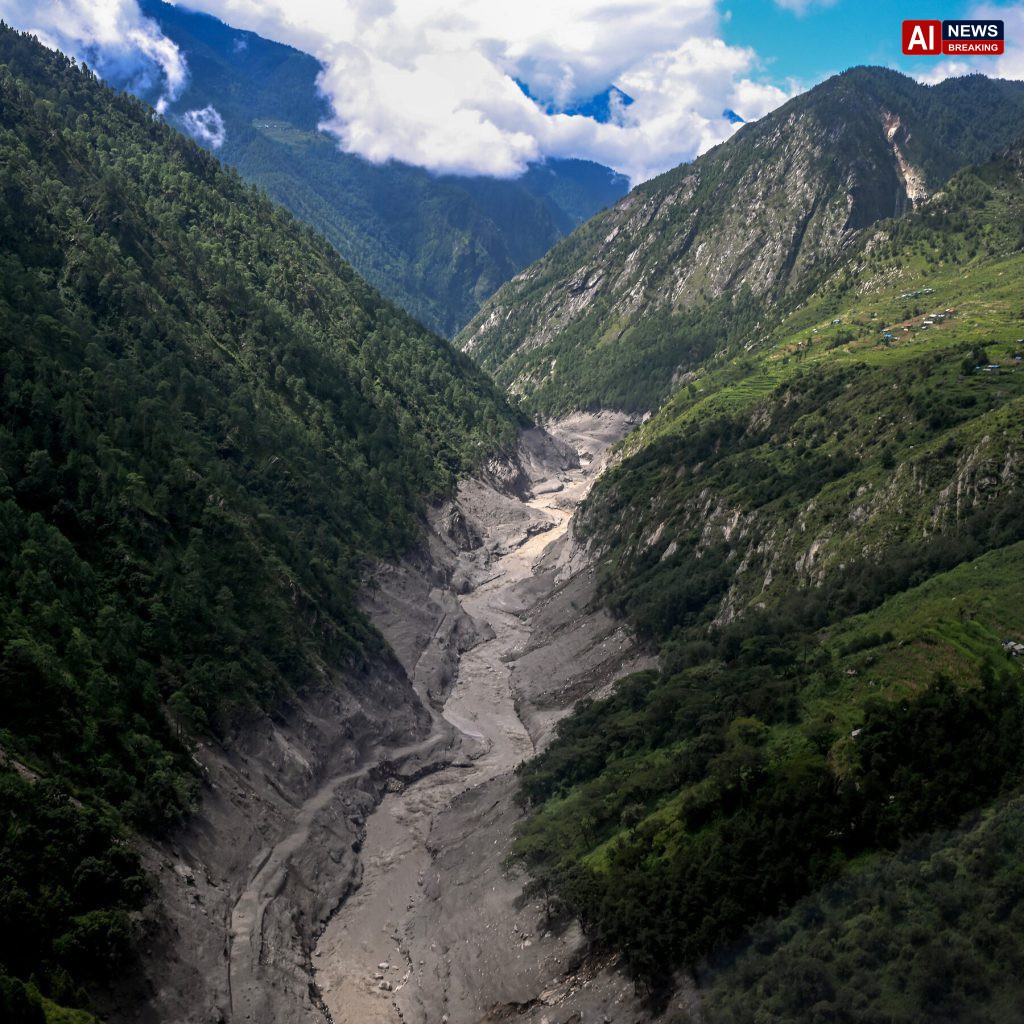
 Jirlu Glacier collapses in Nepal, triggering flood and deaths
**
Disaster Experts Say Nepal Glacier Collapse Was Difficult to Predict - AI News Breaking
jirlu glacier collapses nepal:
The sudden and violent collapse of the Jirlu Glacier in Nepal’s Dolakha district has sent shockwaves through the scientific community, highlighting the profound difficulties inherent in predicting glacial disasters in the Himalayas. The event, which triggered a massive Glacial Lake Outburst Flood that devastated downstream villages and claimed dozens of lives, has sparked urgent discussions among disaster experts regarding the limitations of current monitoring technologies and the necessity for stricter land-use regulations. While satellite imagery and field surveys offer valuable data, the dynamic nature of high-altitude ice masses continues to outpace existing forecasting models, leaving vulnerable communities to catastrophic risks that are often deemed unpredictable until the moment of failure.Researchers from international institutions have emphasized that the geological instability of the region makes precise prediction nearly impossible with current methodologies..
The Jirlu Glacier, like many others in the rapidly warming Himalayan range, is exhibiting signs of accelerated melting due to rising global temperatures. This thermal stress weakens the structural integrity of the ice, leading to sudden calving events and the formation of unstable moraine dams. Experts note that while general trends of glacier retreat are well-documented, the specific timing of a breach or collapse remains elusive..
The complex interplay between internal ice dynamics, subglacial water pressure, and external temperature fluctuations creates a non-linear system that defies straightforward mathematical modeling, resulting in a significant gap between scientific warning and actual disaster occurrence.The challenges in detecting these calamities are compounded by the remote and rugged terrain of the Himalayas. Many of the most dangerous glacial lakes are situated in high-altitude valleys that are inaccessible for much of the year due to snow cover and treacherous weather conditions. This logistical barrier limits the ability of scientists to conduct regular, on-the-ground surveys of lake levels and dam stability..
While remote sensing technologies, such as synthetic aperture radar and optical satellite imagery, provide a continuous stream of data, they lack the resolution and contextual understanding needed to identify subtle precursors to a breach. Small movements in the moraine dam or slight changes in water flow, which could indicate impending failure, often go unnoticed until the event has already begun, leaving downstream populations with little time to react.In response to these limitations, experts have strongly advised against the construction of residential and commercial infrastructure on active floodplains. The devastation witnessed in Dolakha serves as a stark reminder of the intrinsic risk associated with settling in areas historically prone to glacial floods..
Despite traditional knowledge and historical records indicating the danger zones, economic pressures and population growth have driven communities to expand into these vulnerable areas. Researchers argue that this encroachment significantly amplifies the human cost of natural disasters. By banning new construction in mapped floodplain areas, governments can reduce the exposure of civilians to potential outburst floods, thereby minimizing loss of life and property damage when such events inevitably occur.Furthermore, the scientific community is calling for the immediate establishment and clear marking of evacuation routes in at-risk districts..
Existing warning systems often fail because residents do not know where to go or how to move quickly and safely during an emergency. Clear, well-marked pathways that lead to higher ground or designated safe zones are essential for effective disaster response. These routes must be maintained, regularly inspected, and widely communicated to local populations through community education programs..
Without such logistical preparations, even accurate early warnings may prove insufficient, as confusion and panic can hinder evacuation efforts, leading to tragic outcomes that could have been mitigated with better planning.The disconnect between scientific assessment and local governance remains a critical hurdle in disaster risk reduction. While satellite data indicates the growth of hazardous glacial lakes, local authorities often lack the resources and technical expertise to translate these findings into actionable policies. Bridging this gap requires increased investment in local capacity building, including training for municipal workers in risk mapping and emergency management..
International organizations have urged donor countries to support these initiatives, recognizing that long-term resilience depends on empowering local institutions to manage risks proactively rather than reacting to crises after they unfold.Climate change acts as a relentless accelerator in this cycle of vulnerability. As temperatures rise, the volume of meltwater increases, putting additional pressure on moraine dams that are already structurally compromised. Scientists warn that the frequency of glacial outburst floods is likely to increase in the coming decades, making the current passive approach to risk management unsustainable..
The changing climate is not only altering the physical environment but also disrupting traditional ecological knowledge that communities have relied upon for generations to predict seasonal hazards. This erosion of traditional forecasting methods necessitates a stronger reliance on scientific monitoring, yet the technology remains imperfect and resource-intensive.Community engagement is cited by experts as a vital component of any comprehensive disaster risk reduction strategy. Local populations possess intimate knowledge of their environment and historical patterns of flooding, which can complement scientific data..
Integrating these local insights with technical assessments can lead to more accurate risk maps and more effective warning systems. Community-based monitoring programs, where local volunteers are trained to observe and report changes in glacier behavior, can provide real-time data that enhances the utility of satellite observations. Such participatory approaches not only improve early warning capabilities but also foster a sense of ownership and responsibility among residents, encouraging them to take preventive measures.The economic implications of ignoring these risks are substantial..
The cost of rebuilding infrastructure and providing humanitarian aid after a disaster far exceeds the investment required for preventive measures such as relocating high-risk settlements or reinforcing evacuation infrastructure. Governments in the region must prioritize long-term resilience over short-term economic gains. This involves a difficult but necessary process of identifying high-risk zones and implementing strict zoning laws that prevent future development in these areas..
While this may face political resistance due to the displacement of existing communities, the alternative—a cycle of repeated destruction and recovery—is financially and socially unsustainable.International cooperation is essential to address the transboundary nature of these risks. Many Himalayan rivers flow across national borders, meaning that a glacier collapse in one country can have devastating downstream effects in another. Sharing data, technology, and best practices among neighboring nations can enhance regional preparedness and response capabilities..
Collaborative research initiatives can also help refine predictive models by pooling data from multiple monitoring stations, thereby improving the accuracy of forecasts. However, political tensions and differing priorities often hinder such cooperation, underscoring the need for diplomatic engagement focused on shared environmental security.As the Himalayan region faces an uncertain climate future, the lessons from the Jirlu Glacier collapse must be taken seriously by policymakers and scientists alike. The difficulty in predicting such events does not absolve governments of their responsibility to protect citizens..
Instead, it highlights the urgent need for a shift from prediction-focused strategies to resilience-focused actions. By banning construction on floodplains, establishing clear evacuation routes, and strengthening community-based monitoring, nations can reduce the vulnerability of their populations to these unpredictable natural hazards. The path forward requires a concerted effort that combines technological innovation with social empowerment, ensuring that communities are not only aware of the risks but are also equipped to respond effectively when.
Updated: August 28, 2026
Experts urge a shift from unpredictable glacier forecasting to strict land-use bans and clear evacuation plans following Nepal’s deadly Jirlu collapse. Scientists warn that climate change will increase such disasters, making resilient infrastructure and community preparation critical for saving lives.
Since we can’t predict the ice, we must stop building on the path; resilience now means accepting that nature won’t wait for better tech.
Stop gambling with geography and start managing the inevitable, because survival depends on where we live, not what we forecast.