
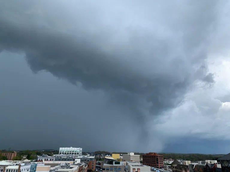
Over 12 Million People Under Threat: Severe Weather Warning Issued for Washington D.C. and Beyond
Washington D.C. – The National Weather Service (NWS) has issued a severe weather warning affecting over 12 million residents across Washington D.C., Maryland, Virginia, and parts of Pennsylvania. Meteorologists warn that the region could face a combination of tornadoes, damaging winds, and flash flooding over the next 48 hours, raising concerns for public safety and transportation systems.
Details of the Warning
According to the latest bulletin from the NWS, the affected areas include:
- Washington D.C. metro area
- Northern Virginia: Arlington, Fairfax, Loudoun, and Prince William counties
- Central and Eastern Maryland: Montgomery, Prince George’s, Anne Arundel counties
- Southeastern Pennsylvania: Philadelphia suburbs and surrounding counties
The warning is valid until Tuesday evening, March 17, 2026, with the potential for rapid escalation depending on storm development. Officials have urged residents to monitor local news, sign up for emergency alerts, and have a safety plan ready.
What Meteorologists Are Predicting
Weather experts report that a strong low-pressure system moving northeast from the Midwest is interacting with warm, humid air from the Atlantic, creating unstable atmospheric conditions. Key risks include:
- Tornadoes: Conditions are favorable for multiple tornado touchdowns, particularly in low-lying and suburban areas.
- Damaging winds: Gusts could exceed 70 mph, capable of uprooting trees, damaging power lines, and causing structural damage.
- Flash floods: Heavy rainfall of 2–4 inches within a short period could lead to localized flooding, especially in urban zones with poor drainage.
Meteorologist Dr. Lisa Montgomery of the NWS stated, “This is a significant weather event. Residents should treat the warnings seriously and avoid unnecessary travel. Stay indoors if possible, and secure outdoor objects that could become projectiles in high winds.”
Impact on Transportation and Public Services
Authorities are already anticipating widespread disruptions to commuting and public transport:
- Airports: Dulles International and Reagan National may experience flight delays or cancellations.
- Roadways: Heavy rain and fallen debris could make highways and secondary roads hazardous.
- Schools and offices: Some school districts in Virginia and Maryland have preemptively announced early closures or remote learning options.
Preparedness Measures for Residents
Officials recommend the following steps for safety:
- Stay informed – Monitor NOAA Weather Radio, local news, and official emergency apps.
- Emergency kits – Ensure you have essentials including water, non-perishable food, flashlights, batteries, and first aid supplies.
- Secure property – Bring outdoor furniture and loose objects indoors to prevent wind damage.
- Plan evacuation routes – Know your nearest storm shelters and safe rooms.
- Avoid travel – Do not drive through flooded areas or under downed power lines.
Power and Communication Concerns
Utility companies in the region are preparing for potential power outages affecting thousands of homes. Emergency response teams are on standby to restore electricity and clear debris quickly. Residents are encouraged to charge mobile devices and keep battery-powered lights handy.
Expert Analysis
Weather analyst James O’Connor explains, “This is not just a local storm; it’s part of a broader pattern of extreme weather events affecting the Eastern Seaboard. Rapid changes in temperature and humidity increase the risk of severe thunderstorms. Communities should treat this as a high-alert situation.”
This article may be prepared with the assistance of artificial intelligence (AI) and is reviewed before publication. While we aim for accuracy and timeliness, readers should verify important facts from official or primary sources. If you believe any information is inaccurate or that any content infringes your rights, please contact ainewsbreaking.com for review and appropriate action.